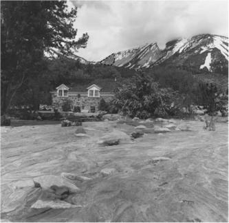

SLIDE MOUNTAIN, NEVADA 1983
 |
 |
| Slide Mountain | Slide Mountain with man at lower section |
|
At about noon on May 30, 1983, a large complex rock and soil slide detached from the southeast face of Slide Mountain, Nevada. Slide Mountain has an elevation of 2956 m on the eastern edge of the Sierra Nevada, and overlooks the Washoe Valley to the east. As elsewhere in the western United States, the winter of 1982-1983 had been unusually wet, with a record snowpack (Wieczorek et al., 1989). A sudden sustained warm period beginning in late May had greatly reduced the snowpack, produced high runoff, and promoted infiltration of water into the subsurface. The increase of moisture content would have increased local pore pressure in discontinuities and in the unconsolidated surficial deposits covering the bedrock, possibly leading to the slope failure. Several types of slope movement were involved, including rock slump, rockfall avalanche, and debris avalanche. The rock slump composed the largest part of the slide and was as thick as 30 m (Watters, 1983). The area of rock slumping consisted of numerous joint-controlled rotated blocks that were 90 m or more wide and several hundred meter long. The initial slope movement involved slumping in unweathered, jointed granodiorite of Cretaceous age. Two of the four major joint sets at Slide Mountain approximately parallel the preslide topography and possibly provided planes of weakness for slope movement. Parts of the rotational slump blocks were subsequently displaced or covered by material from the rockfall avalanche and debris avalanche. Displacement of treelines indicated maximum downslope movement of the rock slump to be about 75 m (Glancy and Bell, 2000). Subsequently, along the northeastern margin of the rockslump zone, a rapidly moving rockfall avalanche of large boulders and a debris avalanche of gravelly sand initiated and entered the northern end of Upper Price Lake, a small reservoir. As described by Glancy and Bell (2000) the material entering Upper Price Lake, displaced most of the lake water, which overtopped and breached a low dam (above right). The water then breached the dam of Lower Price Lake and sent a torrent down the gorge of Ophir Creek. In the steep canyon the rapidly moving water picked up fine and coarse rocky debris. Emerging from the canyon 6 km downstream, the debris flow spread out and deposited over the alluvial fan of Ophir Creek in the Washoe Valley, destroying and damaging houses, causing one fatality, and covering old U.S. Highway 395 (above left). |